
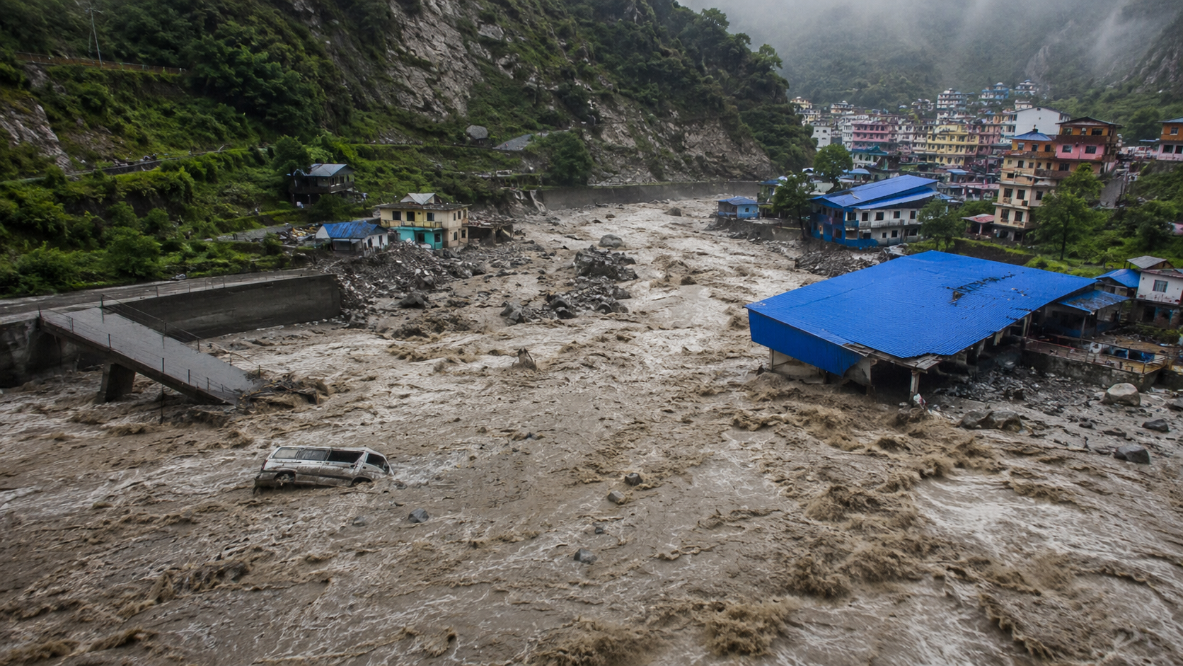
When the Himalayas Collapse: What Really Caused Nepal’s Devastating Floods and Landsl
STV GLOBAL | Investigative Special Report
On the morning of August 26, 2026, life in Nepal’s mountainous Rasuwa district appeared relatively normal.
There was no extraordinary downpour. There was no obvious warning that a devastating disaster was about to unfold.
Yet, high above the valleys, deep in the Himalayas, something catastrophic was already happening.
A massive mass of ice and rock reportedly collapsed from the high mountains, sending debris towards the Lende Khola. The resulting surge of water, mud, boulders and sediment then moved into the Bhote Koshi and Trishuli river systems.
Within just 30 minutes, water levels at some points along the Trishuli River rose by nearly nine metres.
What followed was not simply a conventional flood. It was a complex chain of natural hazards involving an apparent ice-rock avalanche, debris flow and flash flooding.
The central question now is:
How could such a devastating flood occur when there was no exceptional rainfall at the time?
The answer appears to lie not in the clouds, but high above them.
The First Mystery: How Did a Massive Flood Happen Without Extreme Rain?
Floods in Nepal are not unusual during the monsoon season. Heavy rainfall frequently causes landslides, river flooding and flash floods across the Himalayan region.
But the August 26 event appears to have been fundamentally different.
Initial observations suggested that the disaster could not be explained simply by rainfall.
Scientists examining satellite imagery and other evidence have instead pointed towards a massive collapse of ice and rock in the high Himalayas.
The International Centre for Integrated Mountain Development, or ICIMOD, described the event as a potential cascading hazard originating from an ice-rock avalanche.
The avalanche may have introduced an enormous volume of debris into the river system, dramatically altering the river’s behaviour and triggering a devastating downstream surge.
In other words, the immediate source of the flood may not have been the sky.
It may have come from the mountain itself.
What Exactly Came Down From the Mountain?
Satellite imagery provided one of the most important clues.
Before the disaster, the high-altitude landscape showed the characteristic mixture of snow, ice and rugged Himalayan terrain.
After the event, a large scar and extensive debris deposits could be seen across the mountain slope and downstream valley.
Preliminary assessments indicated that a substantial section of ice and rock may have collapsed from an elevation of around 5,200 metres, travelling roughly 1,200 metres downward towards the valley.
The enormous mass of ice, rock and debris then entered the river system.
Experts have described the process as an ice-rock avalanche.
This distinction is important.
A conventional landslide mainly involves soil and rock. An ice-rock avalanche can contain enormous quantities of frozen material, rock and sediment moving at very high speeds.
Once such material enters a narrow Himalayan river valley, the consequences can be catastrophic.
Did the River Become Temporarily Blocked?
This may be one of the most important pieces of the puzzle.
When a huge quantity of rock and ice suddenly enters a narrow river channel, it can temporarily obstruct the river.
Such a natural obstruction is commonly known as a landslide dam.
Water begins accumulating behind the blockage.
If the temporary barrier subsequently fails, the stored water can be released almost instantaneously.
But this time, the water may not travel alone.
It can carry:
water + ice + boulders + mud + sediment + rock debris.
The result can be a powerful debris-laden flood capable of destroying bridges, roads, buildings and other infrastructure within minutes.
ICIMOD has been examining whether such temporary river blockage played a significant role in the August 26 disaster.
Although the precise sequence is still under scientific investigation, the possibility illustrates why Himalayan disasters can rapidly evolve from one hazard into another.
The Earthquake Mystery
Another question emerged immediately after the disaster.
Was an earthquake responsible?
Seismic signals were detected around the time of the event, leading to speculation that an earthquake may have triggered the collapse.
However, subsequent analysis suggested that the seismic signal may have been generated by the enormous ice-rock mass crashing down the mountain rather than by a conventional earthquake.
That possibility significantly changes the understanding of the disaster.
Instead of the familiar sequence of:
Earthquake → landslide → flood
the emerging scenario is closer to:
Ice-rock collapse → avalanche → river obstruction or sudden flow change → debris surge → flash flood.
Scientists are still examining the exact relationship between the seismic signal and the avalanche, so the causal sequence should not yet be regarded as conclusively established.
Why Was the Flood So Destructive?
There is a fundamental difference between an ordinary river flood and a debris-laden Himalayan flash flood.
A normal flood is primarily water.
A debris flow can contain huge quantities of rocks, boulders, mud, sediment and broken vegetation moving together with the water.
The material makes the flow heavier and significantly increases its destructive power.
As the flow moves downstream, it can also erode riverbanks and slopes, picking up additional material along the way.
This can create a self-amplifying process.
The more material the flow carries, the greater its ability to destroy infrastructure and reshape the river channel.
According to ICIMOD’s preliminary observations, water levels at Galchhi on the Trishuli River rose by nearly nine metres within approximately 30 minutes. At Malekhu, the rise was also several metres.
Some monitoring stations were damaged or swept away by the powerful flow.
This highlights a major weakness in conventional flood-warning systems.
The danger may arrive faster than the warning.
Satellite Images Became the Forensic Evidence
The remoteness of the Himalayas makes rapid ground investigation extremely difficult.
Steep slopes, high elevations, damaged roads and continuing hazards can prevent scientists from reaching the source of a disaster immediately.
This is where satellites become crucial.
Before-and-after satellite images can reveal changes in glaciers, mountain slopes, river channels and debris deposits that may otherwise take days or weeks to investigate on the ground.
Satellite observations following the Rasuwa disaster revealed extensive changes in the landscape.
UNOSAT’s satellite analysis also identified significant areas affected by mudflow and rockflow in the region.
These images are more than maps of destruction.
They are increasingly becoming a form of forensic evidence for natural disasters.
But Why Did the Glacier or Mountain Slope Collapse?
This remains one of the most difficult questions.
And the honest scientific answer is:
We do not yet know the complete answer.
Scientists are examining several possible factors, including changes in temperature, snow and ice conditions, geological instability and the structure of the mountain slope.
Some satellite observations reportedly showed signs of warming and snowmelt before the event.
But that does not automatically mean that climate change directly caused the collapse.
ICIMOD has emphasised that while climate change is altering glaciers, snow, permafrost and mountain environments across the Hindu Kush Himalaya, its specific role in triggering this particular event has not yet been conclusively established.
That distinction matters.
It would be scientifically premature to say that climate change directly caused the August 26 collapse.
But it would be equally misleading to ignore the rapidly changing Himalayan cryosphere.
The Himalayas Are Changing
The Himalayan cryosphere includes glaciers, snow, ice and permafrost.
It is one of the most sensitive components of the mountain environment.
As temperatures rise, glaciers lose mass. Snow patterns change. Meltwater dynamics evolve. Permafrost can degrade. Mountain slopes can become increasingly vulnerable to instability in some areas.
These changes do not mean that every landslide or glacier collapse is caused by climate change.
But they can alter the background conditions under which mountain hazards occur.
This is why scientists increasingly focus on compound and cascading hazards rather than isolated disasters.
A single event can trigger another.
A warming environment can alter ice conditions.
A weakened slope can collapse.
The debris can enter a river.
The river can become blocked.
The blockage can fail.
A flash flood can follow.
The flood can trigger another landslide.
And the process can continue downstream.
One Disaster Can Create Another
The August 26 disaster offers a powerful example of this potential chain reaction.
The sequence can be represented as:
Changing climate and cryosphere conditions
↓
Mountain or glacier instability
↓
Ice-rock avalanche
↓
Debris enters river
↓
Temporary river blockage
↓
Sudden release of water and debris
↓
Flash flood and debris flow
↓
Additional landslides
↓
New river blockages and possible flood hazards
This is what scientists call a cascading hazard.
It is one of the greatest challenges facing disaster management in the Himalayas.
A Warning Had Already Come From the Same Region
The latest disaster also raises questions because the Bhote Koshi basin is not unfamiliar with sudden cryosphere-related flooding.
The wider region experienced another major flood event in 2025.
That incident was associated with a glacial lake outburst flood, according to earlier assessments reported by Nepali media.
The recurrence of different forms of ice- and glacier-related flooding within the same broader region raises a serious question:
Are existing risk assessments keeping pace with the changing Himalayan environment?
Why Did People Have So Little Time to React?
This may ultimately become one of the most important lessons from the disaster.
Traditional flood forecasting often depends on monitoring rainfall and river levels.
But an ice-rock avalanche begins somewhere else.
It can start thousands of metres above the river.
By the time the resulting surge reaches a monitoring station downstream, the disaster may already be underway.
That means communities can have very little time to evacuate.
A river gauge may show normal conditions one moment and an extraordinary rise shortly afterwards.
This is why future early-warning systems in the Himalayas cannot focus solely on rainfall and river levels.
They must also monitor the mountains themselves.
What Should Be Done?
Experts increasingly point towards multi-hazard early-warning systems capable of monitoring several interconnected risks simultaneously.
Such systems should include:
- Satellite monitoring of glaciers and mountain slopes
- Detection of rapidly changing snow and ice conditions
- Monitoring of glacial lakes
- Identification of unstable slopes
- Detection of potential landslide dams
- Real-time river-level monitoring
- Seismic monitoring
- Weather and temperature observation
- Rapid satellite-based disaster mapping
- Cross-border data sharing
- Community-level warning and evacuation systems
Most importantly, information must reach people living in high-risk valleys quickly.
A warning sitting on a government dashboard is not enough.
The person living beside the river needs to receive it.
Why Nepal’s Disaster Matters to South Asia
The disaster occurred in Nepal, but its significance extends far beyond Nepal.
The Himalayas are the source of some of Asia’s most important river systems.
Changes in glaciers, snow, rainfall patterns and mountain stability can affect water availability, agriculture, ecosystems and disaster risks across the region.
Bangladesh, as a downstream country within the broader Himalayan river system, has a particular interest in understanding these changes.
This does not mean the Nepal disaster itself should be interpreted as a direct forecast of flooding in Bangladesh.
Rather, it demonstrates why regional hydrological data sharing and cross-border early-warning cooperation are increasingly important.
A disaster that begins in a remote Himalayan valley can have consequences far beyond the place where it starts.
The Bigger Question: Are We Ready for a New Himalayan Risk?
For decades, Himalayan disasters were largely discussed in terms of earthquakes, landslides, avalanches and floods.
But the emerging reality is more complicated.
The hazards are becoming interconnected.
A glacier-related event can trigger a landslide.
A landslide can block a river.
A blocked river can suddenly release a destructive flood.
That flood can trigger further landslides.
In other words, the greatest threat may no longer be a single natural hazard.
It may be the chain reaction between several hazards.
The Warning From the Himalayas
The August 26 disaster leaves South Asia with an uncomfortable question:
Are we preparing for disasters after they happen, or are we learning to recognise the warning signs before they happen?
The science surrounding this particular event is still developing.
Researchers are continuing to determine exactly why the ice-rock mass collapsed, how much of the flood was generated by the avalanche itself, whether temporary river blockage played a decisive role, and what role, if any, climate change played in triggering the event.
But one thing is already clear.
The Himalayas are not a static landscape.
Their glaciers, snow, rivers and mountain slopes are changing.
And as those systems change, the nature of the risks facing millions of people downstream may change with them.
The disaster in Rasuwa was therefore more than another Himalayan flood.
It was a warning about a new generation of compound and cascading natural hazards.
The question is no longer simply whether another flood will come.
The more important question is:
Will we understand where the next one begins before it reaches the people below?


